|
|
Post by tk826 on Jul 21, 2012 14:08:52 GMT -5
Still kicking around this idea... A while back these two screen shots in particular gave me the idea to create a vintage style, folding, "Lloyd's Service station-Road Map". Maps for sale.. 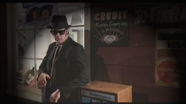 The parent Oil Company... 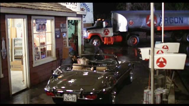 With these ideas combined, I came up w/these concept images... The cover: 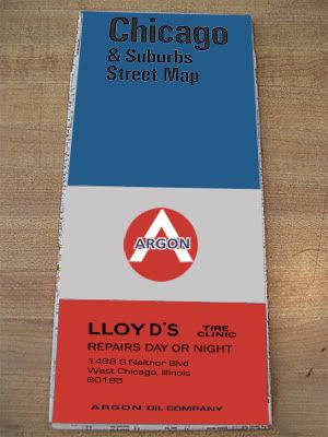 I still haven't determined if Lloyd's should be in Wauconda, IL... or West Chicago, IL... but for this example I used the address where the actual structure was built. I don't believe Lloyd's was actually meant to be in West Chicago. The Bluesmobile ran out of gas in Wauconda and it seems implausible that they would have pushed the car all the way to W.Chi. Scenes of Wauconda are in the film, Wauconda police cars are in the film, and I think that "Wazapamani" might even be based on "Wauconda". The only kink in that thought is that the Ballroom was 106 miles away from Chicago. When I first came up with this idea I found and purchased the same vintage road map as used in the "Blues Brothers: Private" book as well as the the original media press kit. Upon opening, you will find the very same map as above. (Minus the felt tip pen graffiti which can always be added with a real pen)... 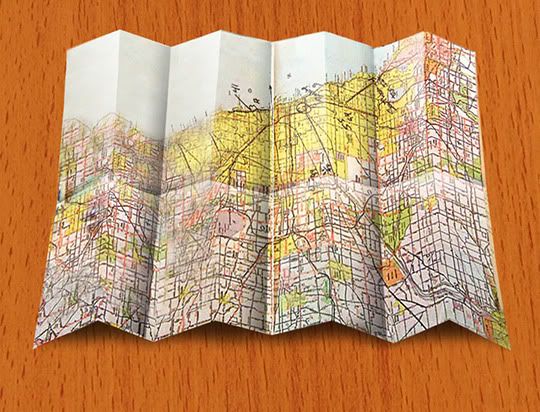 The backside of the map, like the old folding maps, would be filled with various advertisements and logo's, taken from the film... 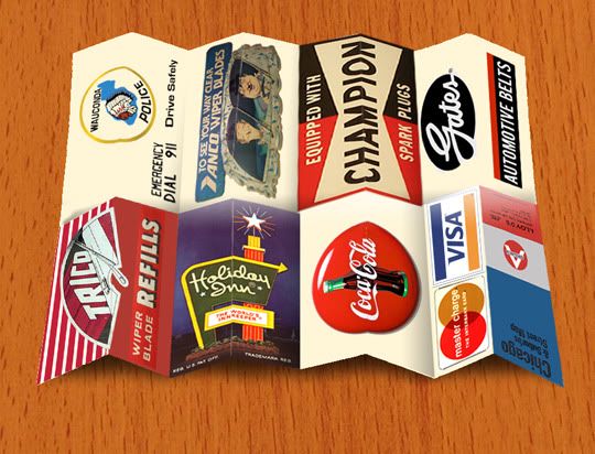 As before, if there is enough interest, it might still become a reality. . |
|
|
|
Post by sigmfsk on Jul 21, 2012 22:09:12 GMT -5
I still haven't determined if Lloyd's should be in Wauconda, IL... or West Chicago, IL... but for this example I used the address where the actual structure was built. I don't believe Lloyd's was actually meant to be in West Chicago. The Bluesmobile ran out of gas in Wauconda and it seems implausible that they would have pushed the car all the way to W.Chi. Scenes of Wauconda are in the film, Wauconda police cars are in the film, and I think that "Wazzipanmi" might even be based on "Wauconda". The only kink in that thought is that the Ballroom was 107 miles away from Chicago. Wazzipanmi? I see a lot of references on the web for Wazzapamani, but the universal script spells it with one Z:  Let's say the brothers: - drove through real-life Wauconda (44 miles from Chicago) - then ran out of gas on the way to the Palace Hotel ballroom - then pushed the blumo (not too far) to LLoyd's - then drove to Lake Wazapamani (106 miles from Chicago) It seems that they couldn't have broken down too close to Wauconda, because that would mean that LLoyds would be close to Wauconda, and it would mean they'd need to drive 50 miles to the ballroom once they got gas. I didn't get the impression it took them that long to drive there. In the movie they only started playing Minnie the Moocher AFTER the blumo arrived (and while they were sneaking in). So maybe we say that they broke down closer to Wazapamani than Wauconda. You could have LLoyds in Wazapamani. But although Lloyds had the map stand, the blues brothers had the map while they were driving through Wauconda, so it would be strange foreshadowing to have a map with LLoyds address on it. And did vintage maps have labels like that? It could just have Rand McNally on it. If the intent is just to provide some interesting blues brothers theme to it, LLoyd's makes sense. But I think it would be cool just to have "franks gas station, Wauconda". Or have it from "Bob's Country Bunker" and Elwood took one on the way out. Lots of options. I'm interested in seeing how it turns out, and it will be a cool prop to have. I need to get my TK826 props up to the MMoA! |
|
|
|
Post by tk826 on Jul 21, 2012 22:51:10 GMT -5
You're right it is "Wazapamani". The above was a case of me typing too fast , without double checking (I went and fixed it). I had always thought it was Wauconda that they ran out of gas because... well it was Wauconda. But I guess in the storyline it could have been anywhere. Lake Waz is a good idea for Lloyd's location. If these ever do get made, I think I will go with that. I based the cover layout off of vintage Standard Oil road maps: 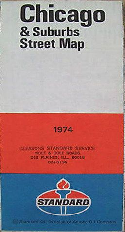 ... and rotated the colors to match the Argon tanker truck. And yeah, they did have a map before running out of gas. That's a good point. But, I can't think of a better place in the film that would carry such a map... Maybe the Shell station... but then it would loose it's Blues Brothers aspect. (Other than the inside map being the same as used in the promo materials) |
|
|
|
Post by sigmfsk on Jul 22, 2012 2:17:04 GMT -5
Lake Waz is a good idea for Lloyd's location. If these ever do get made, I think I will go with that. That's my vote. I think it makes the most geographic sense. And for how they had a map from LLoyds before they made it to LLoyds, it's easy to see that it's not a coincidence. Elwood was clearly familiar with the area around LLoyds, because he knew about the "motel up on the interstate". And it would make sense that when the blumo ran out of gas that he'd be able to convince Jake to help him push the car because Elwood knew that LLoyds was right up the street. And Elwood felt comfortable taking the fan belts and wiper blades - because he already knew about LLoyds lax security, as he'd stolen maps from there before. Look at that; my first effort at fan fiction. I see the script has Lake Waz 240 miles away: I wonder why they changed from 240 to 106? I guess that distance doesn't affect the address of LLoyds except for the zip code. The movie seems the most authoritative reference. |
|
|
|
Post by sigmfsk on Jul 22, 2012 17:38:26 GMT -5
Here are some pics to get the thoughts going: Spring Valley, IL is 104 miles from Chicago, so it would be right next to being 106 Miles from Chicago (Lake Waz). Although Spring Valley is west of Chicago, and that doesn't really jive with Maury saying that Lake Waz is "up north". ---------------- During the making of the movie, one of the actors Stephen Brown (XLI), got separated from the vehicle caravan and drove the "Blues Mobile" 100 miles West on Interstate 80, to the city of Spring Valley, Illinois. When stopping at a gas station for directions he was arrested by the local police for no registration (the plate was a prop), and no valid drivers license. With a telephone call, the set director was more concerned with the return of the vehicle than with the return of his actor. www.imdb.com/title/tt0080455/trivia |
|
|
|
Post by tk826 on Jul 23, 2012 0:05:42 GMT -5
I'm thinking "Spring Valley" might not be the name of a town, but rather the name of the local
housing development/ subdivision that the sign is advertising for.
It states "2 Miles West of Army Trail" (referring to Army Trail Rd.)
and Army Trail is right here by me in the W/NW burbs.
It runs through West Chicago exactly 7.5 miles North of where Lloyds once stood.
Although I'm not sure how you get "2 Miles West" of it as Army Trial runs East-West.
|
|
|
|
Post by sigmfsk on Jul 23, 2012 4:27:46 GMT -5
It states "2 Miles West of Army Trail" (referring to Army Trail Rd.) and Army Trail is right here by me in the W/NW burbs. It runs through West Chicago exactly 7.5 miles North of where Lloyds once stood. Although I'm not sure how you get "2 Miles West" of it as Army Trial runs East-West. I think we're missing part of the sign, and it says "2 miles west of [whatever text is hidden under the OMES] Army Trail". That housing development idea makes sense. If you put LLoyds next to Lake Waz, it would seem strange to advertise a housing development 100 miles away. Somehow the housing development is near "Army Trail Road". This might be more reason to put LLoyds back by Wauconda. |
|
|
|
Post by tk826 on Mar 14, 2013 13:25:49 GMT -5
I don't know why I didn't think of doing this before.  Spring Valley is real. Here is the entrance to the Spring Valley Subdivision. It is located in Carol Stream, Illinois, which is the town directly North of West Chicago. The road that we are "standing on" (running left to right) is Army Trail Rd. 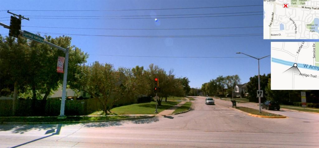 |
|
|
|
Post by tk826 on Mar 14, 2013 14:03:23 GMT -5
The subdivision is 2 miles West of Gary Ave.
So I believe the text that is missing is [Gary Ave on].
|
|
|
|
Post by tk826 on Mar 14, 2013 14:55:00 GMT -5
I think I just confirmed my own theory.  |
|
|
|
Post by sigmfsk on Mar 14, 2013 15:57:14 GMT -5
Hi TK: Nice find on the extra detail. Here's what I get on the last frame of them pulling away: Does the sign say: "2 miles west of Gary Ass[...]n Army Trail" or maybe "2 miles west of Gary Asc[...]n Army Trail" |
|